File:Slater Intro Table1.jpg

Size of this preview: 383 × 599 pixels. Other resolutions: 153 × 240 pixels | 2,929 × 4,579 pixels.
Original file (2,929 × 4,579 pixels, file size: 2.24 MB, MIME type: image/jpeg)
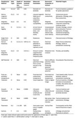
Table 1. Details of borehole geophysical logging methods commonly used at remediation sites. The lateral depth of penetration into the formation and resolution of the measurement are approximate ranges for site investigation. The measured parameters can be derived directly from the acquired data. The recovered properties are obtained through processing and/or inversion of the acquired data.
File history
Click on a date/time to view the file as it appeared at that time.
| Date/Time | Thumbnail | Dimensions | User | Comment | |
|---|---|---|---|---|---|
| current | 15:29, 31 January 2017 | | 2,929 × 4,579 (2.24 MB) | Debra Tabron (talk | contribs) | Table 1. Details of borehole geophysical logging methods commonly used at remediation sites. The lateral depth of penetration into the formation and resolution of the measurement are approximate ranges for site investigation. The measured parameters ca... |
- You cannot overwrite this file.
File usage
The following page links to this file: