File:BJohnson-Article 1-Figure 2.PNG
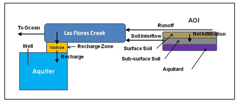
Revision as of 19:58, 7 November 2016 by Debra Tabron (talk | contribs) (Figure 2. Conceptual Site Model used with TREECS™ Advanced Tier 2 for the Zulu Impact Area (ZIA) and receiving waters, Camp Pendleton, CA. The area of interest (AOI) is the ZIA.)
No higher resolution available.
BJohnson-Article_1-Figure_2.PNG (762 × 329 pixels, file size: 98 KB, MIME type: image/png)
Figure 2. Conceptual Site Model used with TREECS™ Advanced Tier 2 for the Zulu Impact Area (ZIA) and receiving waters, Camp Pendleton, CA. The area of interest (AOI) is the ZIA.
File history
Click on a date/time to view the file as it appeared at that time.
| Date/Time | Thumbnail | Dimensions | User | Comment | |
|---|---|---|---|---|---|
| current | 19:58, 7 November 2016 | | 762 × 329 (98 KB) | Debra Tabron (talk | contribs) | Figure 2. Conceptual Site Model used with TREECS™ Advanced Tier 2 for the Zulu Impact Area (ZIA) and receiving waters, Camp Pendleton, CA. The area of interest (AOI) is the ZIA. |
- You cannot overwrite this file.
File usage
The following page links to this file: