File:Slater Intro Table3.jpg

Size of this preview: 800 × 564 pixels. Other resolutions: 320 × 226 pixels | 3,025 × 2,133 pixels.
Original file (3,025 × 2,133 pixels, file size: 1.04 MB, MIME type: image/jpeg)
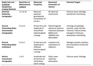
Table 3. Details of four single-hole and crosshole geophysical imaging methods with potential application to contaminated sites. The lateral extent and depth of the surveyed region, and resolution of the measurement, are all typical values for environmental site investigation. The measured parameters can be derived directly from the acquired data. The recovered properties are obtained through processing and/or inversion of the acquired data.
File history
Click on a date/time to view the file as it appeared at that time.
| Date/Time | Thumbnail | Dimensions | User | Comment | |
|---|---|---|---|---|---|
| current | 15:32, 31 January 2017 | | 3,025 × 2,133 (1.04 MB) | Debra Tabron (talk | contribs) | Table 3. Details of four single-hole and crosshole geophysical imaging methods with potential application to contaminated sites. The lateral extent and depth of the surveyed region, and resolution of the measurement, are all typical values for environm... |
- You cannot overwrite this file.
File usage
There are no pages that link to this file.